About Me
- Name: Lucinda Roberts
- Email: lucindar@uoregon.edu
- City: Eugene, OR, USA
- Anticipated graduation: June 2023
- Current employer: UO Infographics Lab
- Favorite projection: Dymaxion Map

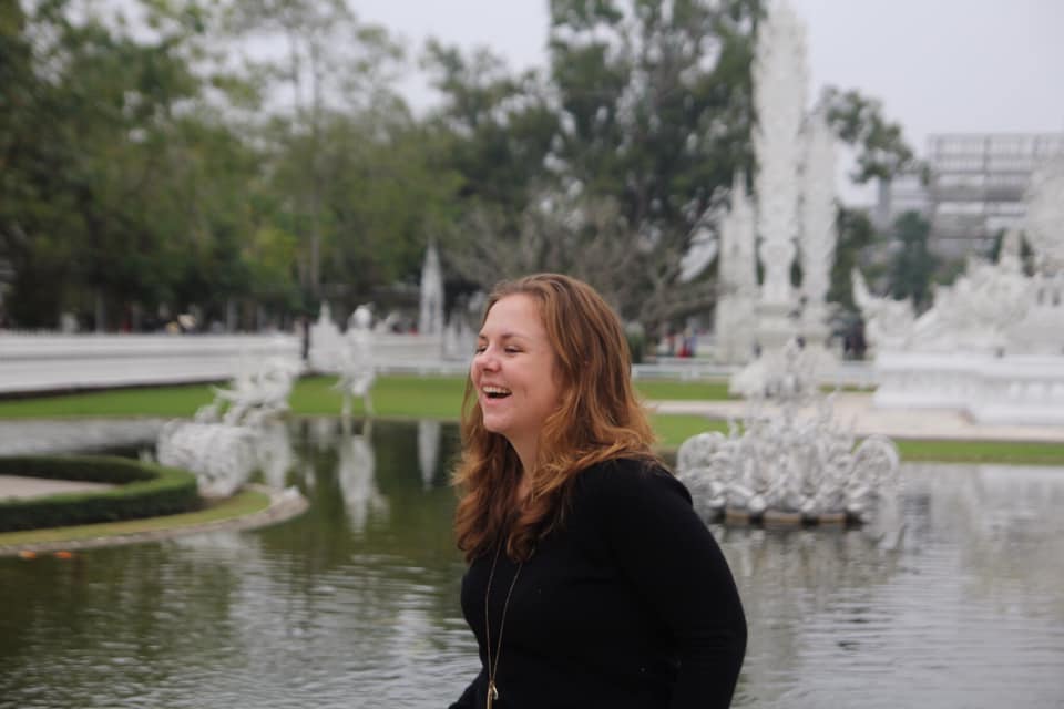
Hello, my name is Lucy and I am a spatial data science major with a minor in global health at the University of Oregon's Clark Honors College. Prior to matriculating into college, I was an exchange student in Thailand, an experience that gave me an appreciation for exploring new cultures and worldviews. I am especially interested in the intersections of art, geography, health, and culture.
Oxford Human Rights Fellow
Attended 2022 Consortium on Human Rights at Oxford University and learned from top leaders and activists on human rights in and around areas of conflict. Co-presented discussion on Cahoots, a policing alternative based in Oregon.
Trussell Family Scholar
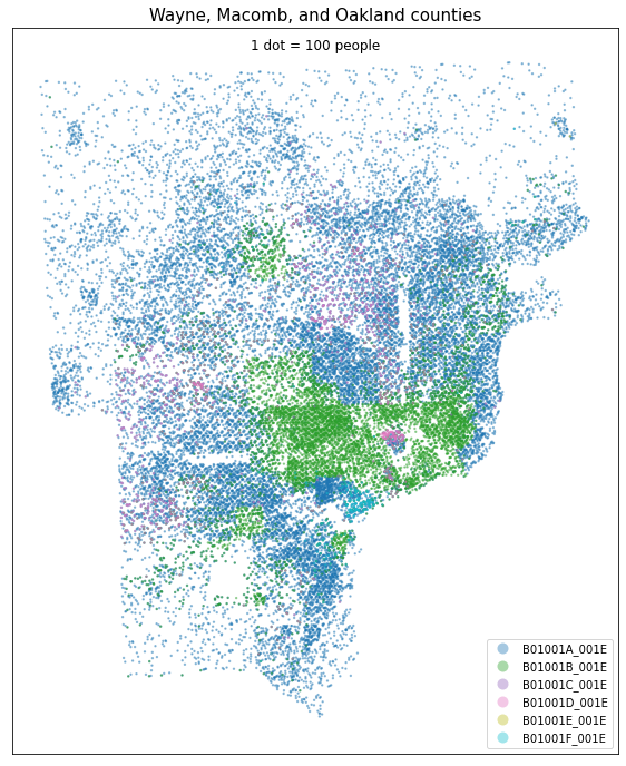
Research award for my work on the research project "Using Python to quantify vaccine accessibility in Detroit, MI," as well as academic merit and an interest in a career serving humanity.
NACIS Scholarship Recipient
"This award recognizes that, through the student’s coursework, they will have demonstrated excellence in print or digital cartography, involvement in cartographic research, or activity in cartographic outreach."
Edward C. Sargeant III Scholar
Awarded to one pre-healthcare student annually who "combines the qualities of idealism, commitment to humanity, openness to alternatives, love of the outdoors, and an interest in preserving the environment."
My Resume
Education
University of Oregon, Clark Honors College
2019 - present
Spatial data science major & global health minor
Coursework: GIScience 2, Adv. Cartography, computer science, the ethics of working internationally, data science, and honors research
Singsamut High School
2018 - 2019
Exchange student
Lived in Thailand as a Rotary Exchange Student
Learned to speak and write Thai with an emphasis on cultural exchange
Volunteer Experience
Humanitarian OpenStreetMap Team
Volunteer mapper and verifier
Manually outlined and verified thousands of buildings and roads in previously unmapped regions.
RiseUp Southern Oregon
Interim volunteer coordinator and donation manager
Coordinated donation sites and volunteer hours in my hometown for a mutual aid network following the 2020 fires
Professional Experience
Undergraduate Cartographer
2020 - Present
Infographics Lab, UO Dept. of Geography
- Worked with a diverse group of research partners to process, normalize, and display spatial and non-spatial data
- Manipulated data and their visualizations in multiple software and programming languages including Excel, ArcGIS Pro, Adobe Illustrator, Python, and HTML5
- Contributed to software development testing and developed tutorial to integrate ArcGIS for Adobe extension into lab workflow
Product Engineer
Summer, 2022
Esri
- Participated as a scrum member on the ArcGIS for Adobe development team, proposing enhancements and logging bugs
- Integrated Adobe Illustrator into an automated regression testing framework using JSX and Adobe's Common Extensibility Platform
Case Investigator
2020 - 2021
Josephine County Public Health
- Called, educated, and checked on COVID-19 cases in rural Oregon
- Worked closely with public health officials to stay on top of newest developments and procedures in COVID-19 response
Skills
Cartographic software
ESRI Suite
Geopandas
Mapbox
Languages
Thai- Advanced
Arabic- Beginner
French- Beginner
Programming
Python
HTML, JS, and CSS
MATLAB
Research
Project management
Problem solving
Collaboration
In the news
~
Another speaker, Maria Gargiulo... explained how she uses data science to estimate undocumented human rights violations. Lucy Roberts... was thrilled; not only was she passionate about social justice issues, but she would also be traveling to the United Kingdom to attend the Oxford Consortium for Human Rights in just a few days... Roberts clacked away on her laptop, drafting an email asking Gargiulo if they could meet.
UO CHC Newsletter
“After months of research, students at the University of Oregon have narrowed potential sites where they think five Cayuse men were buried or reburied after they were hanged for the death of missionary Marcus Whitman."
The Oregonian

"NACIS was pleased to award the 2022 NACIS Undergraduate Student Scholarship in Cartography to Lucy Roberts. . . The NACIS Student Scholarship in Cartography awards an annual scholarship to an accomplished undergraduate student who is majoring in geography or a closely related field while concentrating their course work in cartographic or visualization design or research."
NACIS Newsletter
“The fact that we do not collectively know the burial sites of the Cayuse Five stands in the way of the prospect of repatriation, of justice, of reconciliation, or whatever else we who are living may decide is the wisest course of action,” said Michael Moffitt, the University of Oregon Law School professor
The Register-Guard
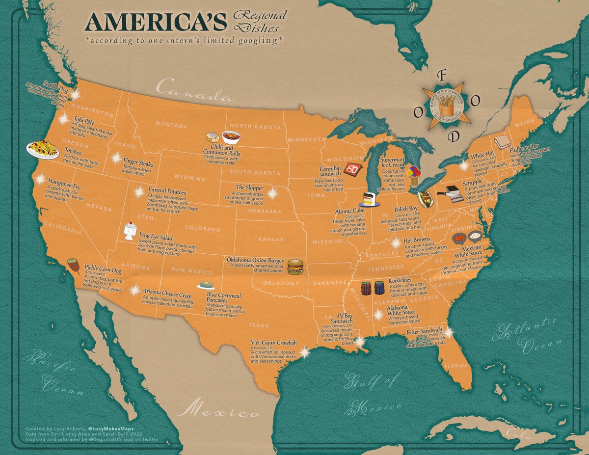
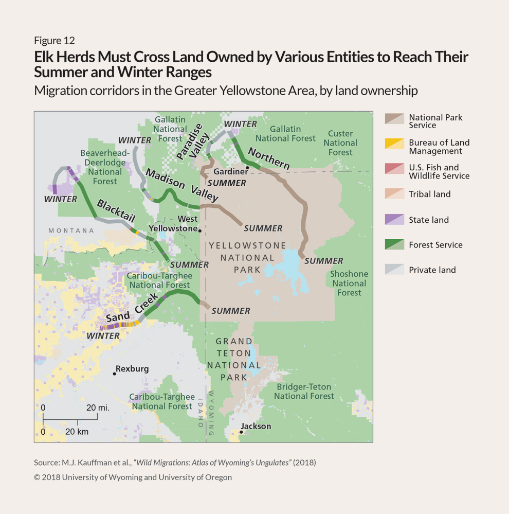
My Portfolio
Hover over each project for more information
~
- All
- Personal Projects
- Infographics Lab
- Writing Samples
